Geog 258: Maps and GIS
February 15, 2006 (Wed)
Global Positioning System
(GPS)
What is GPS?
Global
Positioning System is a network of satellites that continuously transmit coded
information, which makes it possible to precisely identify locations on earth
by measuring distance from the satellites
Currently
two functioning satellite GPS systems (U.S. NAVSTAR and Russian GLONASS), and a
third (E.U. Galileo) planned. Here NAVSTAR will be described
The 3 segments of GPS
The
NAVSTAR system (the acronym for Navigation Satellite Timing and Ranging)
Developed
by
Consists
of three segments
1) space segment (the
satellites)
2) control segment (the ground
stations)
3) user segment (you and your GPS
receiver).

The
Space Segment
It
consists of at least 24 satellites (21 active + 3 operating spares)
They
are in a high orbit about 12,000 miles above the Earth’s surface, circling the
earth twice a day (they are built to last about 10 years)
The
first GPS satellites were launched into space in 1978
The
full constellation of 24 satellites was achieved in 1994
Satellite
transmits low-power radio signals on several frequencies
Each
satellite transmits a unique code, allowing the GPS receiver to identify the
signals
These
coded signals is used to calculate the travel time from the satellite to the
GPS receiver on the Earth
The
Control Segment
It
controls the GPS satellites by tracking them and then providing them with corrected
orbital and clock (time) information
The
User Segment
Consists
of you and your GPS receiver
GPS design
Each
satellite broadcasts unique signals of three types
1) protected or precision
codes (P-codes) → military use (Precise
Positioning Service)
2) coarse acquisition (C/A or
CA) → civilian use (Standard
Positioning Service)
3) status information on
satellites (known as almanac and ephemeris data)
GPS: How does it work?
How
is the location of a GPS receiver determined?
Step1:
where is the satellite?
This
information is encoded in signal (almanac and ephemeris data)
Almanac
data contains the approximate location of satellites
Ephemeris
data contains the corrected location of satellites (processed in control
stations)
Step2:
how far is the satellite away?
This
information is calculated from travel time of signals
Distance
= velocity * travel time
Velocity
is given (i.e. speed of a radio wave)
Travel
time is measured by atomic clocks built on satellites
The
travel time is often delayed due to atmospheric condition which will be
corrected
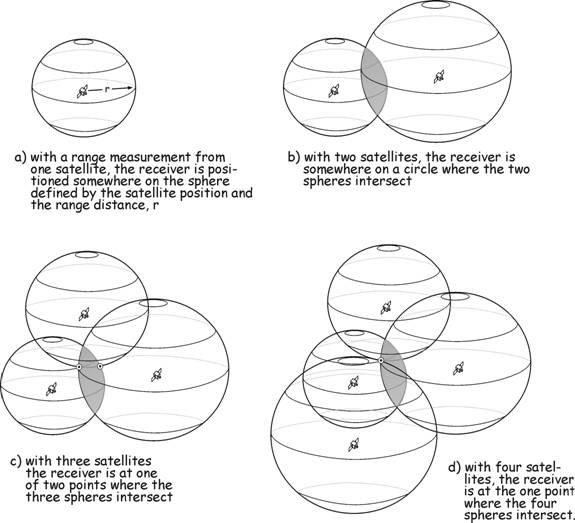
Step3:
triangulation from four satellites
Sources of Errors
Atmospheric
delay: The satellite signal slows as it passes through the atmosphere.
Signal
multi-path: GPS signal is reflected off objects such as tall building
Receiver
clock errors: receiver built-in clock is not precise as much as atomic clocks
Orbital
errors: the location of satellites is not accurate (aka.
Ephemeris errors)
Number
of satellites visible: the more satellites the better the accuracy
Satellite
geometry: the wider angles between satellites the better the accuracy
Intentional
degradation of the satellite signal: “Selective Availability” by DOD; SA was
turned off May 2, 2000
Differential GPS
Improves
positioning accuracy by placing a GPS receiver at a known location (called base
station)
Because
the GPS receiver at a reference station knows the exact location, it can tell
how much atmospheric conditions are affecting satellite signal reception by
comparing true position and GPS measured position (that’s why it’s called
differential). This information (range error) is used to correct for the
positional information at a roving GPS receiver.

WAAS (Wide Area
Augmentation System)
Developed
by
Nationwide
source of GPS correction data for precise aircraft positioning received from 25
ground station
Reading specifications of a
GPS receiver
http://www.garmin.com/products/etrexVista/spec.html
Make
a note of positional accuracy
What can you do with a GPS
receiver?
1) Positioning: where am I?
use Waypoints
2) Navigation: where am I
going? Use GOTO, Track Logs, Routes, Compass
Applications of GPS
Air/sea/land
navigation
Vehicle
tracking: e.g. UPS Tracking
Emergency
management: e.g. Onstar
Car
Navigation System
Surveying
Mapping
…