Geog 258: Maps and GIS
January 30, 2006
Grid Coordinate Systems
Outlines
Making measurement in the
round earth is not quite straightforward (for example, distance of one degree
longitude is not constant, but rather it is a function of latitude). We looked
at how the round earth can be transformed into flat map (i.e. map projection). With
map projection, it is possible to locate things in 2-dimensional (i.e.
projected) coordinate system. Grid coordinate system is convenient because things
can be located by using a simple two-axis reference system (x, y) value. Beside,
we can make measurement (distance, direction and area) between any points by
applying simple geometry in grid coordinate systems.
Two commonly used grid
coordinate systems will be introduced, that is State Plane Coordinate (SPC)
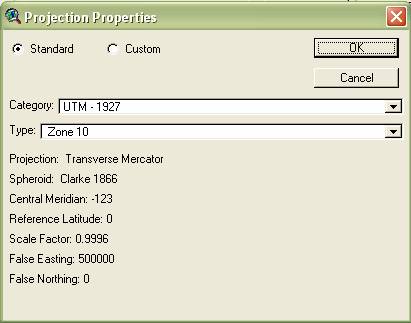
System and Universal Transverse Mercator (UTM)
System. They can be commonly seen in USGS topographic maps (see labels at the edge
of maps). Not knowing about how these coordinate systems are defined can easily
perplex beginner map readers.
Demo:
Go to Terraserver
Explore
Click info tab, which will
give you (x, y) coordinates at the edge of maps
Find out what a world file is
when you download images
Check cursor location (x, y
value reported in status bar for instance in ArcGIS)
when the image is displayed with world file and without world file. How are
they different?
State Plane
Coordinate (SPC) System
Many map uses arise from
municipal needs (e.g. land record), so it may be practical to have coordinate
systems defined within administrative units.
Divide the country into zones,
where zone boundaries follow state and county boundaries
Make a separate grid for each
zone. Each zone has its own projection surface based on the Clarke 1866
ellipsoid (for SPC 27).
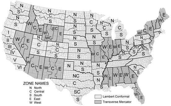
For each zone, appropriate map
projection will be employed given the following rules: If zones have greater
east-west extent (e.g. Washington N, S zones), secant-case Lambert conformal
conic projections will be used such that
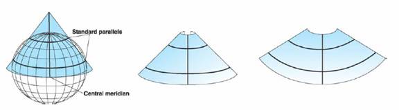
overall distortion can be minimized within a zone. (See below; standard
parallels are lines of tangency of generating globe to developable surface;
scale factor is 1 along standard parallels).
If zones
have greater north-south extent (e.g. NY W, C, E zones), secant-case Transverse
Mercator projections will be used such that overall distortion can be
minimized within a zone. (See
below; grid is converged into central meridian)
Which map projection should
be used for zones in
Which map projection should
be used for zones in
To make coordinate values
positive, it is common to use false northing and easting. For instance, false
easting is usually located 2,000,000 feet west of the central meridian for
Lambert conformal conic.
Until 20 years ago, NAD27 had
been used as datum for State Plane Coordinate system. In 1983, a new geodetic
model GRS80 was adopted.
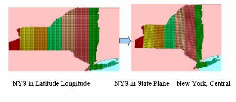
SPC27 is based on
SPC83 is based on GRS80, and
its measurement unit is meter
Universal
Transverse Mercator (UTM) System
It may be convenient to have
grid coordinate systems that can be recognized in international scope. Of
course we have looked at many map projections that simply portray the world
(e.g. Mercator, Mollweide,
Robinson). Are they good enough for giving accurate measurement of location?
What’s the problem with using those map projections?
They use one developable
surface, which necessarily involves too much distortion particularly in the
area further from a line of tangency (mostly equator). Why if we use small
developable surfaces? It can minimize distortion because areas further from a
line of tangency are reduced. UTM divide the world into 60 strip-like zones for
every 6 degree longitude as you can see below.
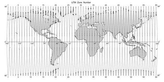
For each zone (numbered 1 to
60 from west to east), secant-case Transverse Mercator
projection centered on the zone’s central meridian is used.
False origin is located
500,000 meters west of the central meridian.
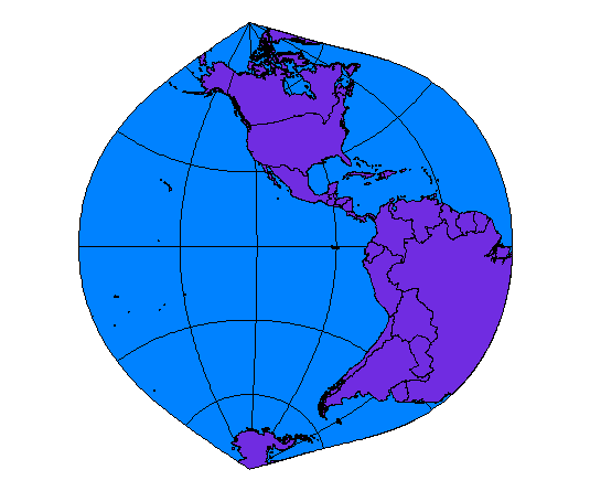
See where a line of tangency
(between generating globe and developable surface) lies in the following
figure. What would be the consequence of making contact there? Why is this projection called “Transverse” Mercator?
Let’s
compare UTM with SPC
|
|
UTM |
SPC |
|
Boundary |
Latitude & longitude |
Administrative boundary |
|
Projection type |
Transverse Mercator |
Lambert conformal conic Transverse Mercator |
|
Geographic scope |
International |
|
|
Measurement unit |
Meter |
Feet (for SPC27) Meter (for SPC83) |
Review
questions
The text below is taken from
a USGS topographic map. Read the text below and answer the followings.
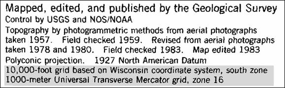
·
What is the source
of this map?
·
If you imagine
light source in the transparent globe being projected onto plane to make this
map, what would be the shape of the developable surface?
·
Which geodetic
model is used in this map? In other word, coordinates are measured relative to
what?
·
What grid
coordinate system is used in this map?