Geog 258: Maps and GIS
January 30, 2006
Map Projections
Outlines
Process for flattening round
earth onto flat map is called map projection. It necessarily involves geometric
distortions. It means that features are not necessarily portrayed at all
locations on maps in a uniform scale.
While pattern of distortion
may vary, it is possible to manipulate one geometric property (e.g. distance)
relative to others (e.g. shape). Which geometric properties are well maintained
such that they are close to the actual scale are important concerns for map
uses. For example, navigator may be more interested in direction than area
whereas area preservation is more critical to portraying varying geographic distribution
in statistical maps.
Another useful way of
classifying map projections is to understand how maps are constructed; Map
projections can be thought of the projection of light source placed in (in
general) transparent globe onto developable surface. The shape of developable
surface and the tangency of developable surface to the globe provide important clues
to understanding the pattern of distortion as well as map uses.
Map projections can be
classified by (1) geometric properties preserved (2) shape of developable
surface.
·
Projection type
{conformal, equal-area, azimuthal, equidistant}
·
Projection family
{planar, conic, cylindrical}
Map
projection process
Topography → Geoid → Sphere or Ellipsoid → Plane
See Figure 3.2
In comparison with the
convenience of having flat maps (that is publishable and portable), the process
for transforming the earth into maps is not straightforward. It’s the
approximation (flattening) of approximation (using datum) of the earth.
Geometric
distortions on map projections
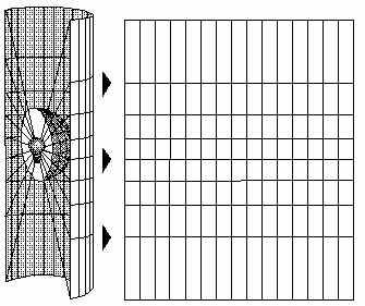
See how flat maps are the
distorted image of round earth by comparing the globe to the map (of course it’s
just one of thousand different maps)
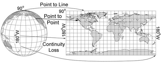
Maps are different from globe
in a way that
Completeness: some maps
cannot show all areas of the earth
Continuity: The left/right
edge of maps is continuous in the globe, but it exhibits breaks in continuity
in the map
Distance: North pole has zero distance in the globe, but it has the length
of equator in the map
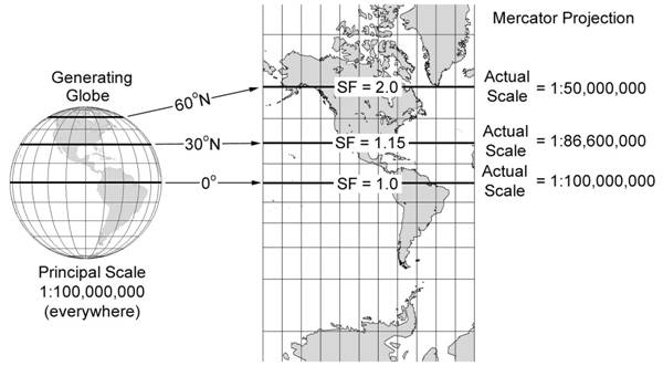
Scale Factor can be used as
an indicator of how much maps are distorted. It is precisely defined as ratio
of actual scale to principal scale. Principal scale can be thought of as the
scale on the generating globe (Generating globe is the globe that is reduced to
the scale of the map). Actual scale can be thought of as the scale on the
plane.
Maps are largely classified
into one of the following maps: {conformal, equidistant, equal-area, azimuthal} depending on which geometric properties are
preserved. Most of the time, all geometric properties (size, shape, distance,
direction) are not preserved on one map at the same time because preserving one
geometric property sometimes involves necessary distortion of other properties.
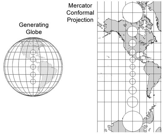
For example, Mercator maps (well known for navigation
maps) preserve shape (circle in the equator is still circle in high latitude)
while area is distorted (size of circle differs).
·
Conformal map: shape and angle is preserved → good for
portraying motion (e.g. wind map, current map)
·
Equidistant
map: distance is portrayed more
closed to the actual scale → good for map where distance measurement is
important (e.g. air navigation map that shows the shortest route as straight
line)
·
Equal-area map: area is preserved → good for statistical maps
·
Azimuthal map: azimuth (global direction) is preserved → good
for navigation
Map
projection family
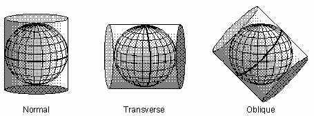
To understand how flat maps
are constructed from spherical earth, imagine you have the followings:
·
Transparent
generating globe where graticules are drawn
·
Light bulb
·
Developable
surface (cylindrical surface in the case below)
The generating globe can be
wrapped by developable surface so that it covers all areas. Then developable surface
can be unfolded, which becomes the flat map as seen on the right (image above).
Therefore, map projections can be thought of the projection of generating globe
onto developable surface.
Where would have the least
distorted image in the map above? Point (or line) of tangency between
developable surface and generating globe exhibits zero distortion (in other
words, true to the scale or Scale Factor is 1)
Depending on which
developable surfaces (cylinder, cones, plane) are
used, map projections are classified into cylindrical, conic, and planar
family.
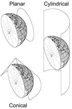
·
Planar: plane is used, it creates a point of tangency, show
the hemisphere
·
Cylindrical: cylinder is used, it create a line of tangency in
the equator (in the case of normal aspect), show the whole extent of the earth
·
Conic: cone is used, it creates line of tangency in
mid-latitude, good for portraying areas with large west-east extent
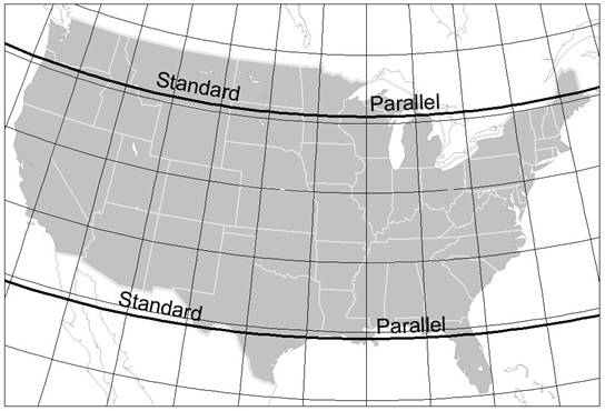
The line of tangency is called
standard line (tangent case) or standard parallel (secant case). See Figure 3.8
to find out how tangent and secant case are different
Commonly
used projections
Gnomonic
Belongs to planar family
(generating globe is projected onto plane)
Light source at the center of
the generating globe
Any straight line drawn in
this map is great circle (it gives you the shortest path between two points) because
images projected onto the surface come out of the center of the earth (see
figure above), and great circle passes through the center of the earth (see
Figure 3.14)
Azimuthal Equidistant
All straight lines drawn from
the point of tangency are great-circle (because this is planar family where
features shown in the point of tangency comes out of the center of the earth)
Distance along meridians is
true to the scale
Good for portraying exact
distance from the central point to other points radiated outwards (see
Figure3.15)
Mercator
Maybe most well known map
projections
Rhumb lines (line of constant azimuth) are straight lines
on this map
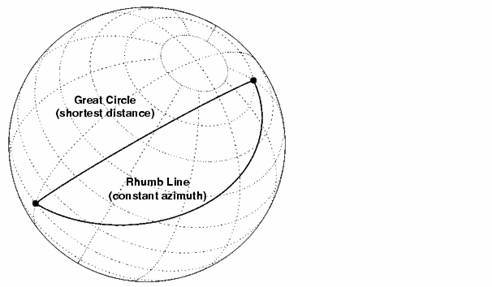
Maps can’t show the pole area
because it requires extending map northward into infinity
Which projection family is Mercator?
How do you know?
What would be the proper use
of this map? Is this map suitable for wall maps of the world?
Transverse Mercator
Makes meridian a line of
tangent (between developable surface and generating globe
Good for portraying areas
with large north-south extent
Albers Equal-Area Conic
This is commonly used to
portray conterminous
Standard parallel minimizes overall
distortion
Review
questions
Which projection family would
be suitable for different purposes? Which geometric properties ought be preserved for different purposes? Why do you thing
so?
|
Map purposes |
Projection family or Specific projection name |
Geometric properties |
|
Shortest route from any
points |
|
|
|
World population by
countries |
|
|
|
|
|
|
|
Statistical map of |
|
|
|
Navigation |
|
|