Geog 258: Maps and GIS
January 25, 2006
Earth Coordinate
Reading: Chapter 1 (The Earth
and Earth Coordinates)
Outlines
Understand different ways to
pinpoint the location of a feature shown on a map.
·
Earth as a sphere
→ horizontal datum (geographic coordinates)
·
Earth as an
oblate ellipsoid → horizontal datum (geodetic coordinates)
·
Earth as a geoid → vertical datum
How did
Eratosthenes measure earth’s circumference?
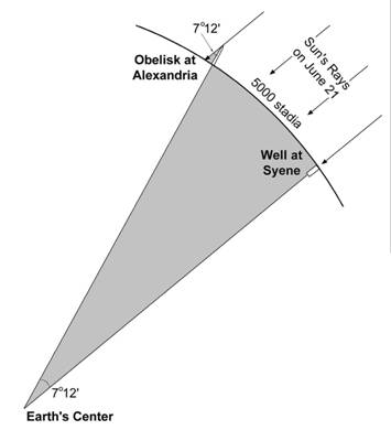
Angle of shadow at
Angle of shadow at Syene is 90 degree
Distance between
7º12΄
: 5000 = 360 º : x
x = 250,000 stadia (it’s about 29,000 statute miles)
Current value is 24,907
status miles
Geographic
Coordinates
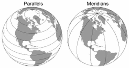
Parallel: line parallel to equator
Graticule: arrangement of parallels and meridians
Latitude and longtitude is the numbering system for parallels and
meridians
Geographic latitude and
longitude
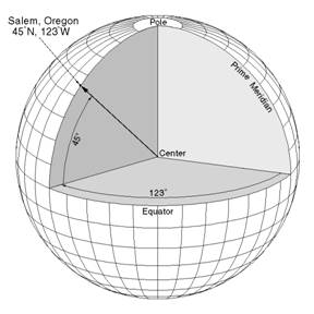
Longitude is the offset angle at the equator from prime
meridian
Latitude is the angle from the equator to the place of
interest
Expressed in degree, minute,
and second
Can be converted into decimal
degree (= degree + minute/60 + second/3600)
South latitude and west
longitude is often labeled by a negative sign instead of the letters S and W in
the computer
Determining time difference
based on longitude
360 degree: 24 hour = ? degree: 1 hour
Every 15 degree strip becomes
a time zone
Longitude for
Longitude for
24pm 12pm 0am
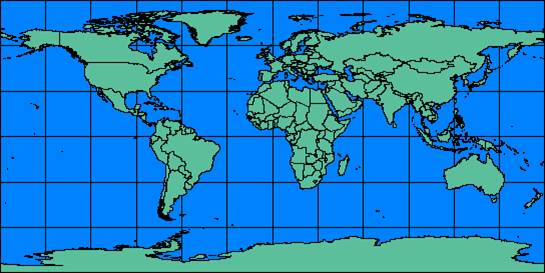
Unfolded geographic
coordinate grid (don’t forget this grid necessarily gives very much distorted
image at the high latitude)
Prime meridian is located at
the center
Edges are the international
datelines where a day changes
Properties
of the Spherical Graticule
As meridians are converging
toward the pole, the length of a degree of longitude, measured east-west along
parallels decreases from the equator to the pole.
The ground distance of a
degree of longitude at the equator would be earth’s circumference divided by
360 (=69.2 mile)
What would be the ground
distance of a degree of longitude at 50° North?
![]()
![]()
![]()
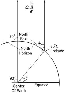
Cos 50 º = x / r
where r is the radius of the earth, x is the length of red
line
x = cos
50 º * r
Circumference (2πr) is
proportional to radius
So r can be replaced with the
length of one degree longitude at the equator
Cos 50º * 69.2 = 0.642788 * 69.2 = 43.83811 mile
The ground distance of one
degree longitude at 60 º will be the half that of one degree longitude at the
equator because cosine 60 º is 0.5
Great circle
Can be obtained by cutting
the earth in half (cutting the earth so that it passes through the center of
the earth)
Gives the shortest route
Used in air navigation
Shortest route between
Geodetic
Coordinates
Is the earth a perfect
sphere?
Not really
It’s more close to ellipsoid
(more flattened at the equator)
Why is that?
Measurement of the location
of geographic feature based on ellipsoid-like earth would be more accurate than
based on the sphere-like earth.
More accurate measurement of
coordinates based on ellipsoid is called geodetic coordinates (Why more
accurate? Because ellipsoid is a better approximation of size/shape of the
earth)
There are
more than one reference ellipsoids used in real world. Some ellipsoid fits the
best in some area. For example, a red dashed line fits the best in the upper
left, but it fits the other side of the earth very poorly (see lower right).
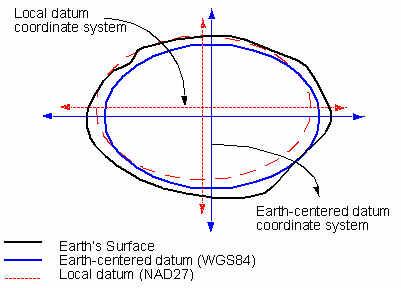
US mapping agency has used
North American Datum 1927 (NAD27) until 20 years ago. It is based on reference
ellipsoid called
As GPS gets increasingly
popular, it is necessary to define earth-centered datum (ellipsoid) so that
coordinates are measured relative to a single (uniform) reference ellipsoid.
WGS84 is earth-centered datum, and coordinate values given by GPS is measured
on the basis of this datum.
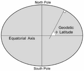
Geodetic coordinates are
based on an oblate ellipsoid; geodetic latitude is the angle between the
equator and the line perpendicular to the point of interest (see below)
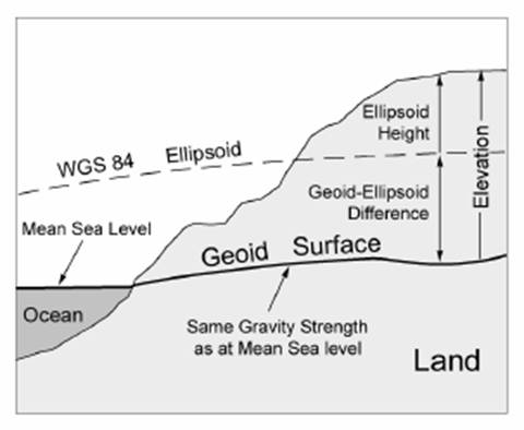
Earth as a Geoid
Elevations and water depths
are measured relative to vertical reference datum
Elevations are measured
relative to mean sea level (MSL)
MSL is the average of all low
and high tides at a particular location over a 19 year lunar period
In principle, MSL is the
surface of same strength of gravity
MSL can be extended to the
land area
Such surface is not same as
ellipsoid due to varying land density (thus gravity, leading to undulating
surface)
This approximation of the
earth that serves as the basis for vertical value measurement is called geoid
Review
questions
How are longitude and
latitude determined?
Is parallel a great circle?
How are geodetic coordinates
different from geographic coordinates?
What is an oblate ellipsoid?
What is a geoid?
Would spot elevation (read
from contour maps) be necessarily the same as z-value obtained from GPS receivers. (GPS uses WGS84 as the basis for x,y,z measurements)?