Remote Sensing
Aerial Photograph and Satellite Image
January 20 (Fri)
Complementary readings: Bolstad 2005 and NASA online tutorial
·
Aerial photography: photo taken from camera mounted on aircraft
·
Satellite imaging: digital image recorded by electronic scanner mounted
on satellite or spacecraft
Which
began earlier? (with the development of what?)
Which
would have a higher spatial resolution? (in which
altitude?)
Are
they analog or digital? (output format)
Which
is more flexible? (can satellite be launched any time?)
Which
would provide geographic coverage in a systematic manner?
Which
is equipped with wider spectral bands? (does air photo has thermal-infrared
sensors?)
How
would post-processing be different? (film handling, image processing)
The
gap between the two gets narrower (spatial resolution, digital vs. analog)
Classifying Aerial Photograph
Different kinds of aerial
photographs are available depending on
·
Film emulsion:
black-and-white, true-color, and color-infrared films
·
Camera’s height:
low, medium, and high altitude photography
·
Camera’s vantage
point: vertical and oblique photography
Color-infrared
aerial photo was used in WWII for detecting camouflage
Geometric Distortions of Aerial Photograph
Most of aerial photo provides
a perspective view. Perspective views give a geometrically distorted image of
the Earth surface. Distortion in aerial photographs comes primarily from two
sources: camera tilt and terrain variation.
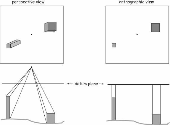
Viewed from a fixed viewing
location viewed from infinite height
Central perspective photo Planimetrically correct photo
Scale is not constant on
aerial photo Scale is constant
on orthophoto
Geometric distortion on an
aerial photograph due to camera tilt

Geometric distortion on an
aerial photograph due to terrain variation

A, B: location on the
ground surface; will be shown in a and b on the aerial photo
A’, B’: location on the
reference datum surface; will be shown in a’ and b’ on the orthophoto
Objects in the higher
elevation (than datum surface) will be displaced outwards (a’ to a) in the
aerial photo. Objects in the lower elevation will be displaced inwards (b’ to b)
in the aerial photo.
How Digital Orthophotoguads
(DOQs) are made
USGS map product
Step1:
Aerial photos are scanned
Step2:
Digital aerial photos are rectified (i.e. geometric distortion caused by camera
tilt and terrain variation) using software (rectification requires determining
ground control point)
Step3:
Digital aerial photos are indexed into quadrangles (or georeferenced)
so its location can be identified in a uniform fashion
Classifying Satellite Imagery
Satellite systems have been
launched with different purposes and in different times;
Three key aspects of
resolutions can be identified from any satellite imagery
Satellite systems can be
classified on the basis of
·
Spatial
resolution: High-resolution vs. low-resolution (how detailed?)
·
Types of light
source: Passive vs. active (does a sensor provide energy source also?)
·
Types of spectral
bands: Pancromatic vs. multispectral
(how many spectral bands?)
·
Special purposes:
earth-observing, meteorological, thermal-infrared
Earth
Observation Satellite: Past
http://www.ersc.wisc.edu/resources/EOSP.php
Earth
Observation Satellite: Current
http://www.ersc.wisc.edu/resources/EOSC.php
Meteorological Satellites
http://www.ersc.wisc.edu/resources/Met.php
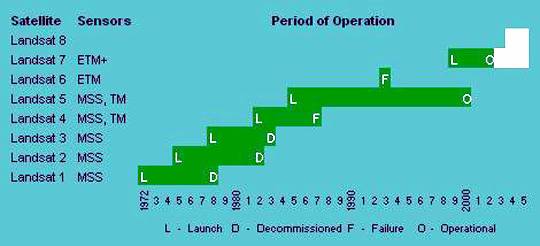
Landsat
NASA Earth Resources
Observation Systems (EROS), 1972~
Multispectral imaging capabilities
Different sensors (e.g. MSS,
TM, ETM, ETM+) are defined by different scanner type,
different spectral bands, orbit and so on
SPOT
Commercial
satellite
Has a higher spatial resolution and more continual coverage than Landsat
Has
stereoscopic imaging capability (useful for topographic mapping)
RADAR image
Uses
microwave as an energy source
It’s
an active sensor system → nighttime
mapping capabilities
It’s
not influenced by weather condition (see atmospheric window) → all-weather mapping capabilities
SLAR (Side-looking airborne
radar):
It’s
mounted on aircraft
Small
depression angle is effective in accentuating subtle vertical changes → widely used for geologic studies (can
highlight geological features)
SIR (Space
Imaging Radar) or SAR
(Synthetic Aperture Radar):
It’s
mounted on space shuttle; has ground penetration ability → used for archaeological site detection
Review questions
What is the difference
between aerial photo, orthophoto, and DOQs?
Discuss advantage and
disadvantage of aerial photo vs. satellite imagery
What is the advantage of
using active sensor systems?
What is the advantage of
using spectral bands beyond visible wavelength ranges (0.4-0.7 micron)?